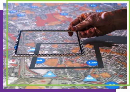
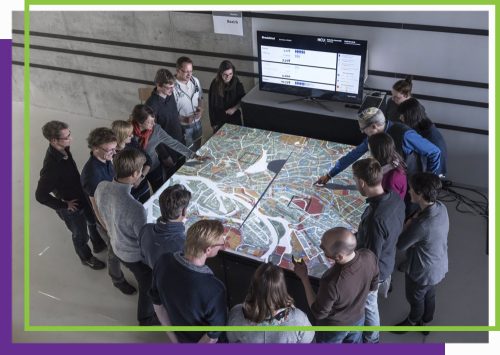
 Finding Places was a participatory process that ran in 2016 with the aim to address the refugee crisis in Hamburg by engaging citizens, experts, and authorities in identifying suitable plots of land for refugee accommodations. The process was coordinated by the Hafencity University Hamburg with direct funds from the Municipality of Hamburg. It involved workshops that used the City Scope tool developed by the Media Lab City Science group at MIT (Massachusetts Institute of Technology) that projects city maps and plot details, allowing participants to suggest and distribute potential sites. The results were then reviewed by a task force to validate the specific plots. The majority of shelter placements occurred independently of the process, showcasing a limited impact on the overall accommodation strategy. While the project yielded tangible results in terms of providing shelter for a portion of the expected refugees, the broader context of political decisions, city dynamics, and the establishment of the media lab played crucial roles in shaping the trajectory for more advanced digital participation platforms.
The inception of the Finding Places tool, born out of the pressing need to address the refugee crisis in Hamburg. Introduced as a quick mock-up to contend with the imminent influx of approximately 22,000 refugees in 2016, the tool was conceived amid the tumultuous aftermath of the city’s failed Olympic bid in 2020. The urgency of the refugee crisis, coupled with political turmoil, set the stage for a multifaceted challenge.
The political landscape in Hamburg at that time was marked by discord, stemming not only from the failed Olympic bid but also from the public’s vehement opposition to the proposed Olympic Village in central urban areas. The public opinion successfully challenges the ruling party’s plans and developed a precarious political situation. The city’s leadership, having narrowly survived the fallout of the Olympic debacle, now faced the complex challenge of addressing the refugee crisis from the Syria war.
Accommodating thousands of refugees in the affluent neighbourhoods of Hamburg presented a formidable task for the political leadership. The fear of public backlash and potential political catastrophe loomed large, as distributing the refugees equitably across the city’s wealthier areas risked sparking local protests.
Referring specifically to urban planning, as this is the specific case in this project, formal participation is a mandatory phase that occurs late in the planning process. According to German planning law –Law for Broadening the Public Participation and for the Standardization of the Procedures for Determining Sectoral Plans– , once the proposal plan has been drawn up, it needs to be published for public scrutiny. This formal participation involves objections from the public, typically expressed when critical issues arise, like the construction of a significant structure.
However, recognising the limitations of this formal participation and the potential waste of resources, many urban projects now include an informal participationInformal methods of participatory public engagement are those that occur as part of routine human interaction, outside of political institutions, and may involve dialogue, collective decision-making, and deliberation. process much earlier in the planning stages. While not compulsory, municipalities and communities have learned that understanding public objections and sentiments early in the process is beneficial.
These informal participation processes often take the form of co-creative workshops or other digital and non-digital methods. They help collect valuable knowledge and information from the public, even though it can be resource-intensive and challenging, especially for abstract projects lacking visualisations.
Despite the increasing political will to embrace informal participation in urban planning, planning administrations and urban development agencies remain ambivalent. While recognising the benefits, they struggle to integrate the results of these campaigns into established planning procedures. The challenge lies in fitting new information and inputs from participatory processes into existing planning frameworks, hindering the effective utilisation of valuable insights gained through these efforts.
The city administration allocated a substantial budget directly to the university. This financial injection was part of a broader initiative that stemmed from a decision by the then-mayor, Mr. Olaf Scholz, who had been inspired by the MIT Media Lab during a visit to the U.S. To justify the establishment of a local media lab at Hamburg City University, significant funding was provided to support its projects, including the Finding Places initiative.
The media lab, established in 2015, found a significant project in the form of the Finding Places initiative, which was tasked with addressing the challenge of accommodating thousands of refugees.
The university, tasked with orchestrating a process that engaged the public in determining suitable locations, embarked on a series of co-creative workshopsCo-creation is the practice of collaborating with other stakeholders to guide the design process. Participants with different roles align and offer diverse insights, usually in facilitated workshops.
However, the process faced methodological challenges. Contrary to the initial idea, these workshops were not conducted in each neighbourhood of the city but were centralised at the university, each time focusing on one specific area of the city. Any individual interested in participating was welcome, and the participants were not pre-selected based on residency or other criteria. Therefore, only those who were willing to travel to the university participated, and these were not necessarily representative of the area under discussion on that specific workshop.
Despite that, the workshops numbering around 30 with an average of 8 to 10 participants each, therefore engaging hundreds of participants aimed to identify potential sites for refugee shelters through interactive tools, maps, and projections.
The inception of the Finding Places project emerged from a distinctive collaboration between the political leadership and the university, as a response to the looming refugee crisis in Hamburg. To navigate the challenge of accommodating thousands of refugees while avoiding direct political entanglement, city authorities enlisted the university’s assistance. The university was tasked with designing a co-creative and participatory process to address the issue, allowing the city leadership to maintain a certain distance from direct political involvement.
Participants took part in two-hour workshops at the university. These structured sessions guided participants through a focused exploration, beginning with an understanding of the overall scenario—the imminent arrival of 20,000 refugees. The workshop’s underlying purpose is to ensure an equitable distribution across city neighbourhoods, preventing undue burden on any single area. Participants transition from the broad perspective of refugee numbers to a detailed examination of Hamburg’s map, encompassing districts and neighbourhoods.

The participants engage in a meticulous search for suitable plots of land around their neighbourhoods, aiming to identify potential sites for refugee accommodations. This detailed exploration emphasises the need for thorough scrutiny in the selection process, highlighting the comprehensive approach taken during these workshops.
The process involves two intricately linked components: the workshop process and the utilisation of the CityScope tool. The CityScope tool, functioning as a projection system, is integral to the workshop process. Two tables were employed, with the first projecting the entire city map, indicating coloured representations of public and private land. Legal constraints, such as designated industrial use or nature reserves, excluded specific areas from consideration. The second table, with higher resolution, focused on individual neighbourhoods, displaying detailed information about city-owned plots, including ownership details, size, and constraints.
Participants suggested and distributed refugee accommodations across available sites, leading to a political discussion involving administrative decisions on whether to accept or reject proposed sites. Workshop results were then submitted to planning and immigration authorities. A task force within these authorities reviewed the results, addressing the complexity of certain suggestions. The final consolidated and verified results were published on a public webpage.
The actual influx of refugees in Hamburg was approximately half of the initial estimate, totalling around 10,000 individuals. Despite the lower-than-expected numbers, the challenge of accommodating refugees persisted. Numerous shelters were constructed throughout Hamburg, with only one or two settlements influenced by the Finding Places process. The majority of shelter placements occurred independently of the process, showcasing a limited impact on the overall accommodation strategy.
The workshop outcomes identified a handful of potential sites for refugee accommodation. However, the subsequent validation process, involving planning authorities, ownership assessments, and consideration of permissible uses, further narrowed down the selection. Ultimately, approximately 70 to 80 refugee accommodations, often in the form of containers, were built based on the outcomes of the Finding Places project.
While the project yielded tangible results in terms of shelter for a portion of the expected refugees, the broader context of political decisions, city dynamics, and the establishment of the media lab played crucial roles in shaping the trajectory and outcomes of the Finding Places initiative. The project serves as a testament to the intricate interplay between political initiatives, academic endeavours, and community participation in addressing pressing urban challenges.
Accordingly, based on these outcomes, the interest and knowledge around digital tools has grown. Over the past 7-8 years the HCU Digital City Science, TUD Knowledge Architecture has assembled a team of technologists, programmers, IT engineers, and data engineers who possess both creative and technical skills. The result is the creation of new but replicable, well-functioning systems that are open source, allowing for collaborative development by a global community. These are: i) Location Finder that enables strategic decision-making about city-owned plots of land facilitating the mapping and checking functionalities against available land, accounting for the city’s dynamic property transactions; ii) U-CODE, developed for collective urban design and participatory processes. It originated from the Finding Places project and has evolved into a versatile tool applicable worldwide, promoting low-threshold collective urban design and co-creation; and iii) Micado, a platform offering guidance on various processes, including navigating the city, automated translation for numerous languages, and interfaces for migrants, public administration, and civil society organisations. Micado aims to streamline and simplify the complex integration processes faced by newcomers across Europe, having been piloted in cities like Bologna, Madrid, Antwerp, and Hamburg.
These tools demonstrate the commitment to developing solutions tailored to specific user groups, from expert decision-makers to individuals engaged in participatory processes and those navigating integration challenges.
One important remark, already mentioned above, is the representation of the participants in the neighbourhoods’ object of the specific workshops. Whether attendees were residents of that area was not verified, highlighting a notable methodological flaw. Moreover, attendees were required to travel to the university for the workshops, engaging in a place-finding process using maps, interactive tools, and projections. This emphasises the impracticality for those living far from the university.
Regarding the workshop process and the City Scope tool, it was resource-intensive, with significant public funds allocated to conduct workshops for only accommodating very few refugees. Additionally, the tool was at its initial stage and recognised as a mock-up, therefore having shortcomings (especially in terms of functionality) and technological glitches during the workshops.
Digital tools require adjustment to specific use cases. The major factor for their success is their open-source nature. The ambition is not to have proprietary systems but to ensure that people in specific sites can not only use the tools but also locally develop them further. The open-source quality enables local technical versatility, allowing people to access the code, understand it, and modify it for their specific contexts.
Technological spin-offs of City Scope, described earlier, are intentionally designed for universal application globally. Except perhaps Location Finder, U-CODE and Micado, are constructed with the aim of universality. While open source is a crucial aspect, the documentation is equally vital for the survival and uptake of platforms like Mikado. The narrative outlines the ongoing efforts to enhance the explanatory lines in the source code for Micado, ensuring its continued use and adaptation in various locations.
Then, the public’s contributions often lack refinement, with people providing sketches or input on digital platforms that may be difficult to interpret. Public authorities, on the other hand, are frequently unprepared to integrate this digital input effectively into their processes. With the spin-off tools, there has been an exploration into the use of language processing AI tools to condense and organise the valuable knowledge from these contributions. This approach aims to transform the raw data into digestible “nuggets” that planners can more easily work with, bridging the gap between the public’s input and the administration’s ability to use it effectively.
Finding Places is an example of a digital participatory tool to address urban challenges. It showcases the potential of technology, such as the City Scope tool, to facilitate citizen engagement and decision-making in urban planning. However, the case also reveals the limitations of participatory processes in the face of complex political and social dynamics, such as the allocation of refugees, as evidenced by the challenges of integrating the outcomes into the broader urban planning framework and the limited impact on the overall accommodation strategy.
Additionally, the City Scope tool was at its initial stage and recognised as a mock-up, with shortcomings in terms of functionality and technological setbacks during the workshops.
However, the Finding Places case provides valuable insights into the opportunities and challenges of digital participatory platforms in urban planning and gave a boost to new technologies.
Based on an interview conducted with Prof. Dr.-Ing. Jörg Rainer Noennig (joerg.noennig@hcu-hamburg.de), Professor of Digital City Science at Hafencity University Hamburg on 13 September 2023.
Here is the brochure showing the results of the project: https://repos.hcu-hamburg.de/bitstream/hcu/488/1/FindingPlaces_Results_RZ_LowRes_170914_1.pdf.

This project has received funding from the European Union’s Horizon 2020 research and innovation programme under grant agreement No 959420.